
2 hrs ago - Updated
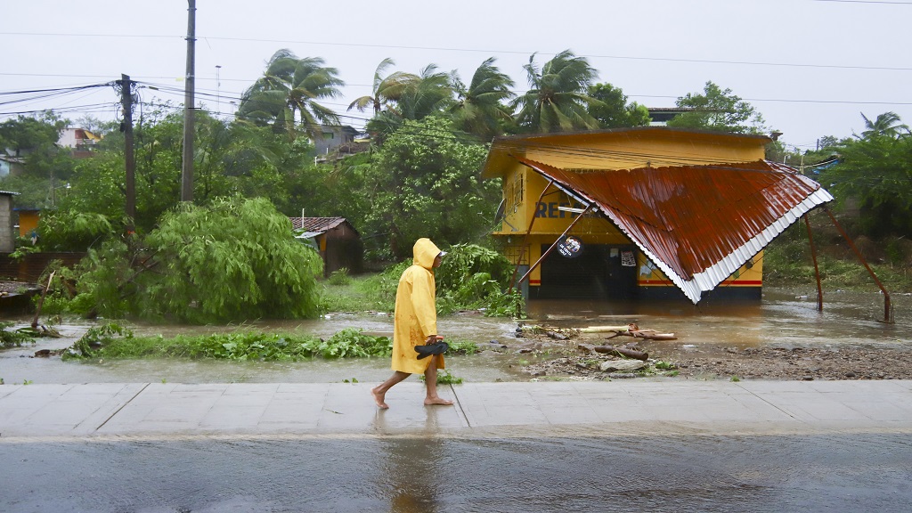
A person walks in the rain after the passing of Hurricane John in Marquelia, Mexico, Tuesday, Sept. 24, 2024. (AP Photo/Luis Alberto Cruz)
Two major weather systems are bringing heavy rain, high winds and more to Mexico's southern Pacific coast on one side and the Caribbean on the other.
Tropical Storm John struck Mexico late Monday with life-threatening flood potential after growing into a Category 3 hurricane in a matter of hours. It came ashore near the town of Punta Maldonado before weakening back to tropical storm status early Tuesday and was expected to weaken rapidly. Still, the US National Hurricane Centre warned that the storm’s slow pace and heavy rains could cause potentially catastrophic flash flooding and mudslides.
Meanwhile, Tropical Storm Helene formed in the Caribbean Sea on Tuesday after bringing heavy rains and big waves to the Cayman Islands. Forecasters warned the storm could strengthen into a major hurricane en route to the southeast US Hurricane watches were in effect for Florida’s Tampa Bay and from Englewood to Indian Pass, as well as for eastern Mexico from Cabo Catoche to Tulum and for Cuba’s Pinar del Rio province.
Meanwhile, President Joe Biden on Tuesday afternoon approved Florida's state of emergency declaration. He also ordered federal assistance to supplement state, tribal and local response efforts due to emergency conditions resulting from Tropical Storm Helene that began Monday.
Florida Governor Ron DeSantis declared a state of emergency in 61 of the state’s 67 counties ahead of the storm expected to become Hurricane Helene. The governor continues to urge residents across much of the state to prepare for potentially significant impacts, from the rural Panhandle region down the Gulf Coast to southwest Florida. The storm is expected to arrive as soon as late Thursday.
“We’re anticipating impacts, I mean, 100, 200 miles (161 to 322 kilometres) outside the eye of the storm, you could see with winds and you could see with surge,” DeSantis said. “We are going to see significant impacts no matter what happens.”
DeSantis said the storm is reminiscent of Hurricane Michael, a category 5 hurricane that rapidly intensified and caught many residents off guard before plowing a path of destruction across the western Panhandle. Communities that are still rebuilding from previous storms could get battered again, DeSantis warned.
Source
More From
Contrary to the notion that is held in some circles, the Jamaica Constabulary Force (JCF), similar to its international counterparts, has the technology in place to photograph and send tickets to the
Custos Rotulorum for Clarendon, Edith Chin recently handed over one of two retrofitted container houses, developed under an initiative she spearheads, to a family residing in Rocky Point in the parish
The flash flood watch which was issued for low-lying and flood-prone areas of southern and north-western parishes, has been extended to the remaining parishes locally.
The watch will remain i
The four-storey multipurpose structure, scheduled for completion in 2026, represents investment of $1.5 billion, with the possibility of an additional $400 million to $600 million for the buildout of
Samuda active on campaign trail; contest also features former PNP member and UIC educator
Reggae enthusiasts enjoyed breathtaking city views while soaking in fresh melodies from Mortimer’s latest tracks. The acclaimed crooner showcased exclusive songs from his new album, "From Wi
Related News

Skyn by Dr Kym’s essential tips for teens and college students
Alumina shipments resume as Jamalco rebuilds after Hurricane Beryl

Australia beat England by 68 runs for 2-0 lead in ODI series